
Fil:Adare Peninsula map.jpg
Størrelse af denne forhåndsvisning: 463 × 599 pixels. Andre opløsninger: 185 × 240 pixels | 371 × 480 pixels | 594 × 768 pixels | 792 × 1.024 pixels | 1.475 × 1.908 pixels.
Fuld opløsning (1.475 × 1.908 billedpunkter, filstørrelse: 769 KB, MIME-type: image/jpeg)
|
|
Denne fil er fra Wikimedia Commons. Beskrivelsen af filen fra Commons er gengivet nedenfor. |
Beskrivelse
| Beskrivelse |
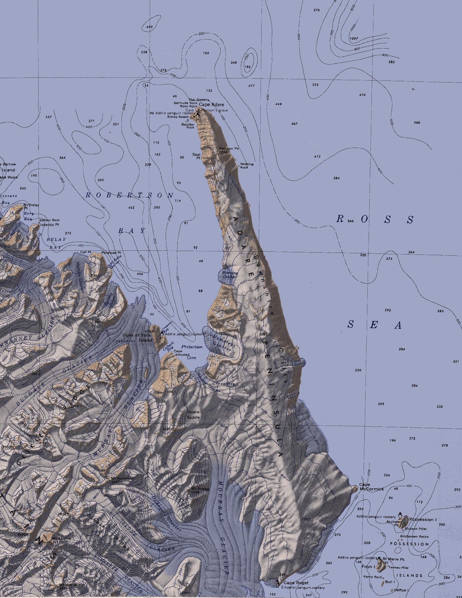
English: Map of the Adare Peninsula west of the Ross Sea. |
| Dato | |
| Kilde | File:C71188s5 Ant.Map Cape Adare.jpg |
| Forfatter | U. S. Geological Survey |
Licensering
This image is in the public domain in the United States because it only contains materials that originally came from the United States Geological Survey, an agency of the United States Department of the Interior. For more information, see the official USGS copyright policy.
|
Filhistorik
Klik på en dato/tid for at se filen som den så ud på det tidspunkt.
| Dato/tid | Miniaturebillede | Dimensioner | Bruger | Kommentar | |
|---|---|---|---|---|---|
| nuværende | 11. mar. 2010, 23:51 | | 1.475 × 1.908 (769 KB) | 4ing | == {{int:filedesc}} == {{Information |Description={{en|1=Map of Possession Islands in the Ross Sea.}} |Source=File:C71188s5 Ant.Map Cape Adare.jpg |Author=U. S. Geological Survey |Date=1968 |Permission= |other_versions= }} <!--{{ImageUpload|basic}}- |
Filanvendelse
Den følgende side bruger denne fil:
Global filanvendelse
Følgende andre wikier anvender denne fil:
- Anvendelser på be.wikipedia.org
- Anvendelser på ceb.wikipedia.org
- Anvendelser på de.wikipedia.org
- Transantarktisches Gebirge
- Kap Adare
- Adare-Halbinsel
- Kap Roget
- Robertson Bay
- Adare Saddle
- Newnes-Gletscher
- Moubray-Gletscher
- Protection Cove
- Colbeck Bay
- Herzog-von-York-Insel
- Murray-Gletscher
- Dugdale-Gletscher
- Geikie Ridge
- Archer Peak
- Possession Island (Antarktika)
- Possession Islands
- Kap McCormick
- Berg Bay
- Burnette-Gletscher
- Boulder Rock
- Ridley Beach
- Bull Island (Antarktika)
- Kemp Rock
- Heftye Island
- Foyn Island
- Crescent Bay
- DeAngelo-Gletscher
- Mount Robinson (Viktorialand)
- Mount Ruegg
- Dickson Pillar
- Downshire-Kliffs
- Favreau Pillar
- Gertrude Rock
- Rose Rock
- Hanson Peak
- Hargreaves Peak
- Nameless Glacier
- Kristensen Rocks
- Nestling Rock
- Seal Point (Viktorialand)
- St. Marie Peak
Vis flere globale anvendelser af denne fil.