Bruger:Gorbi/Kladde1

Koordinater: 43°42′29″N 1°03′36″Ø / 43.708°N 1.060°Ø / 43.708; 1.060
Fra Wikipedia, den frie encyklopædi
Dokumentation[opret]


en:Template:Infobox French region
Skabelon:Infoboks fransk region

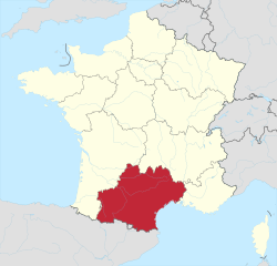
Occitanie[redigér | rediger kildetekst]

Side by side comparison
{{Infoboks fransk region}}{{Bruger:Gorbi/Kladde1}}{{Bruger:Gorbi/Kladde1a}}
Occitanie
[[Fil:|200px|Flag for ]]
Hovedstad Toulouse
Areal 72.724 km²
Regionspræsident Carole Delga
Indbyggertal
 - Indbyggere, år 2009
 - Befolkningstæthed

5.573.000
77 indb./km²
Arrondissementer
Kantoner 269
Kommuner 4.565
Départementer Ariège Ariège
Aude Aude
Aveyron Aveyron
Gard  Gard
Haute-Garonne  Haute-Garonne
Gers  Gers
Hérault  Hérault
Lot Lot
Lozère  Lozère
Hautes-Pyrénées  Hautes-Pyrénées
Pyrénées-Orientales Pyrénées-Orientales
Tarn Tarn
Tarn-et-Garonne Tarn-et-Garonne
Map of
Gorbi/Kladde1

Occitanie
Land Frankrig Frankrig
Kantoner 269
Kommuner 4.565
Præfektur Toulouse
Départementer Ariège Ariège
Aude Aude
Aveyron Aveyron
Gard  Gard
Haute-Garonne  Haute-Garonne
Gers  Gers
Hérault  Hérault
Lot Lot
Lozère  Lozère
Hautes-Pyrénées  Hautes-Pyrénées
Pyrénées-Orientales Pyrénées-Orientales
Tarn Tarn
Tarn-et-Garonne Tarn-et-Garonne
Politik
 • Regionsråds­præsident Carole Delga
Areal
 • Total 72.724 km²
Indbyggertal
 (2009)
 • Total 5.573.000
 • Tæthed 76.632 indb./km²
Tidszone UTC+1 (CET)
 • Sommertid UTC+2 (CEST)
Gorbi/Kladde1
[[File:Map of highlighting {{{county}}}.svg|300px|alt=Kort over med markeret.|Placering i delstaten [[]]]]
Placering i delstaten [[]]
Map of the United States highlighting
placering i USA
Land USA USA
Side by side comparison
{{Infoboks fransk region}}{{Bruger:Gorbi/Kladde1}}{{Bruger:Gorbi/Kladde1a}}
{{{native_name}}}
[[Fil:{{{image_flag}}}|200px|Flag for {{{common_name}}}]]
Hovedstad Toulouse
Areal 72724 km²
Regionspræsident {{{Regional president}}}
Indbyggertal
 - Indbyggere, år 2009
 - Befolkningstæthed

403.257
6 indb./km²
Arrondissementer {{{arrondissements}}}
Kantoner {{{cantons}}}
Kommuner {{{communes}}}
Départementer {{{départements}}}
[[Fil:{{{image_map}}}|200px|Map of {{{common_name}}}]]
Occitanie

Occitània
Occitanies flag
Flag
Occitanies byvåben
Byvåben
Land Frankrig Frankrig
Præfektur Toulouse
Départementer
Politik
 • Regionsråds­præsident Carole Delga (Socialist Party)
Areal
 • Total 72724 km²
Indbyggertal
 (2012)
 • Total 5626858
Tidszone UTC+1 (CET)
 • Sommertid UTC+2 (CEST)
Gorbi/Kladde1
flag
Flag
[[File:Map of highlighting {{{county}}}.svg|300px|alt=Kort over med markeret.|Placering i delstaten [[]]]]
Placering i delstaten [[]]
Map of the United States highlighting
placering i USA
Land USA USA
Side by side comparison
{{Infoboks fransk region}}{{Bruger:Gorbi/Kladde1}}{{Bruger:Gorbi/Kladde1a}}
{{{native_name}}}
[[Fil:{{{image_flag}}}|200px|Flag for {{{common_name}}}]]
Hovedstad {{{capital}}}
Areal {{{area}}} km²
Regionspræsident {{{Regional president}}}
Indbyggertal
 - Indbyggere, år 2009
 - Befolkningstæthed

403.257
Fejl i udtrykket: Uventet <-operator. indb./km²
Arrondissementer 36
Kantoner 249
Kommuner 4454
Départementer Ariège (09)
Aude (11)
Aveyron (12)
Gard (30)
Haute-Garonne (31)
Gers (32)
Hérault (34)
Lot (46)
Lozère (48)
Hautes-Pyrénées (65)
Pyrénées-Orientales (66)
Tarn (81)
Tarn-et-Garonne (82)
[[Fil:{{{image_map}}}|200px|Map of {{{common_name}}}]]
Gorbi/Kladde1
Land Frankrig Frankrig
Arrondissementer 36
Kantoner 249
Kommuner 4454
Départementer Ariège (09)
Aude (11)
Aveyron (12)
Gard (30)
Haute-Garonne (31)
Gers (32)
Hérault (34)
Lot (46)
Lozère (48)
Hautes-Pyrénées (65)
Pyrénées-Orientales (66)
Tarn (81)
Tarn-et-Garonne (82)
Indbyggertal
 • Total Skabelon:Population de France/dernière pop
Tidszone UTC+1 (CET)
 • Sommertid UTC+2 (CEST)
Gorbi/Kladde1
[[File:Map of highlighting {{{county}}}.svg|300px|alt=Kort over med markeret.|Placering i delstaten [[]]]]
Placering i delstaten [[]]
Map of the United States highlighting
placering i USA
Land USA USA


Occitania

Occitanie (fransk)
Occitània (occitansk)
A view of Artigues in the Pyrenees
Occitanias flag
Flag
Occitanias byvåben
Byvåben
Koordinater: 43°42′29″N 1°03′36″Ø / 43.708°N 1.060°Ø / 43.708; 1.060
Country  France
Prefecture Toulouse
Departments
Politik
 • President of the Regional Council Carole Delga (PS)
Areal
 • Total 72724
 • Rang 3rd
Indbyggertal
 • Total Skabelon:France metadata Wikidata
 • Tæthed auto
Demonym Occitans
Tidszone UTC+01:00 (CET)
 • Sommertid UTC+02:00 (CEST)
ISO 3166-kode FR-OCC
GDP
  • €159 billion (nominal; 2015)[1]
  • $200 billion (PPP; 2016)
GDP per capita €27,449 (nominal; 2015)[2]
Side by side comparison
{{Bruger:Gorbi/Kladde1}}
Gorbi/Kladde1

Occitanie (fransk)
Occitània (occitansk)
Artigues i Pyrenæerne
flag
Flag
byvåben
Byvåben
Koordinater: 43°42′29″N 1°03′36″Ø / 43.708°N 1.060°Ø / 43.708; 1.060{{#coordinates:}}: kan ikke have mere end én primær tag per side
Land Frankrig Frankrig
Kantoner 269
Kommuner 4.565
Præfektur Toulouse
Départementer
13
Politik
 • Regionsråds­præsident Carole Delga (2021-2028) (PS)
Areal
 • Total 72.724 km²
Indbyggertal
 (2009)
 • Total 5.573.000
 • Tæthed 76.632 indb./km²
Tidszone UTC+1 (CET)
 • Sommertid UTC+2 (CEST)
ISO 3166-kode FR-OCC


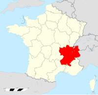
Rhône-Alpes[redigér | rediger kildetekst]

Side by side comparison
{{Infoboks fransk region}}{{Bruger:Gorbi/Kladde1}}{{Bruger:Gorbi/Kladde1a}}
Région Rhône-Alpes
Flag for Rhône-Alpes
Hovedstad Lyon
Areal 43.698 km²
Regionspræsident Jean-Jack Queyranne
Indbyggertal
 - Indbyggere, år 2009
 - Befolkningstæthed

6.174.040
141 indb./km²
Arrondissementer 25
Kantoner 335
Kommuner 2.879
Départementer Ain Ain
Ardèche Ardèche
Drôme  Drôme
Isère Isère
Loire Loire
Rhône Rhône
Savoie Savoie
Haute-Savoie  Haute-Savoie
Map of Rhône-Alpes
Gorbi/Kladde1

Région Rhône-Alpes
flag
Flag
Land Frankrig Frankrig
Arrondissementer 25
Kantoner 335
Kommuner 2.879
Præfektur Lyon
Départementer Ain Ain
Ardèche Ardèche
Drôme  Drôme
Isère Isère
Loire Loire
Rhône Rhône
Savoie Savoie
Haute-Savoie  Haute-Savoie
Politik
 • Regionsråds­præsident Jean-Jack Queyranne
Areal
 • Total 43.698 km²
Indbyggertal
 (2009)
 • Total 6.174.040
 • Tæthed 141.289 indb./km²
Tidszone UTC+1 (CET)
 • Sommertid UTC+2 (CEST)
Gorbi/Kladde1
flag
Flag
[[File:Map of highlighting {{{county}}}.svg|300px|alt=Kort over med markeret.|Placering i delstaten [[]]]]
Placering i delstaten [[]]
Map of the United States highlighting
placering i USA
Land USA USA
Side by side comparison
{{Infoboks fransk region}}{{Bruger:Gorbi/Kladde1}}{{Bruger:Gorbi/Kladde1a}}
{{{native_name}}}
[[Fil:{{{image_flag}}}|200px|Flag for {{{common_name}}}]]
Hovedstad Lyon
Areal 43698 km²
Regionspræsident {{{Regional president}}}
Indbyggertal
 - Indbyggere, år 2009
 - Befolkningstæthed

403.257
9 indb./km²
Arrondissementer {{{arrondissements}}}
Kantoner {{{cantons}}}
Kommuner {{{communes}}}
Départementer {{{départements}}}
[[Fil:{{{image_map}}}|200px|Map of {{{common_name}}}]]
Rhône-Alpes
Rhône-Alpes' flag
Flag
Rhône-Alpes' byvåben
Byvåben
Land Frankrig Frankrig
Præfektur Lyon
Départementer
Areal
 • Total 43698 km²
Indbyggertal
 (2014-01-01)
 • Total 6449000
Tidszone UTC+1 (CET)
 • Sommertid UTC+2 (CEST)
ISO 3166-kode FR-V
BNP (2014)[3] nr. 2nd
Total 207 milliarder euro (US$228 bn)
pr. indbygger €32,000 (US$35,200)
NUTS-region FR7
Hjemmeside www.rhonealpes.fr
Gorbi/Kladde1
flag
Flag
[[File:Map of highlighting {{{county}}}.svg|300px|alt=Kort over med markeret.|Placering i delstaten [[]]]]
Placering i delstaten [[]]
Map of the United States highlighting
placering i USA
Land USA USA
Side by side comparison
{{Infoboks fransk region}}{{Bruger:Gorbi/Kladde1}}{{Bruger:Gorbi/Kladde1a}}
{{{native_name}}}
[[Fil:{{{image_flag}}}|200px|Flag for {{{common_name}}}]]
Hovedstad {{{capital}}}
Areal {{{area}}} km²
Regionspræsident {{{Regional president}}}
Indbyggertal
 - Indbyggere, år 2009
 - Befolkningstæthed

403.257
Fejl i udtrykket: Uventet <-operator. indb./km²
Arrondissementer 25
Kantoner 335
Kommuner 2879
Départementer Ain (01)
Ardèche (07)
Drôme (26)
Isère (38)
Loire (42)
Rhône (69)
Métropole de Lyon (69)
Savoie (73)
Haute-Savoie (74)
[[Fil:{{{image_map}}}|200px|Map of {{{common_name}}}]]
Gorbi/Kladde1
Land Frankrig Frankrig
Arrondissementer 25
Kantoner 335
Kommuner 2879
Départementer Ain (01)
Ardèche (07)
Drôme (26)
Isère (38)
Loire (42)
Rhône (69)
Métropole de Lyon (69)
Savoie (73)
Haute-Savoie (74)
Indbyggertal
 • Total 6449000
Tidszone UTC+1 (CET)
 • Sommertid UTC+2 (CEST)
Gorbi/Kladde1
[[File:Map of highlighting {{{county}}}.svg|300px|alt=Kort over med markeret.|Placering i delstaten [[]]]]
Placering i delstaten [[]]
Map of the United States highlighting
placering i USA
Land USA USA
  1. ^ "Produits intérieurs bruts régionaux et valeurs ajoutées régionales de 1990 à 2015 | Insee".
  2. ^ "Produits intérieurs bruts régionaux et valeurs ajoutées régionales de 1990 à 2015 | Insee".
  3. ^ http://ec.europa.eu/eurostat/documents/2995521/7192292/1-26022016-AP-EN.pdf/602b34e8-abba-439e-b555-4c3cb1dbbe6e
  4. ^ Source Insee